


Skitour Riederhütte u. Großer Höllkogel


- Flatly
Interactive elevation profile
Create PDF
Tour-Details
Starting place: 4802 Ebensee
Destination: 4802 Ebensee
duration: 4h 9m
length: 10,3 km
Altitude difference (uphill): 639m
Altitude difference (downhill): 638m
Lowest point: 1.543m
Highest point: 1.849m
difficulty: medium
condition: medium
panoramic view: Great panorama
Paths covering:
snow, unfixed
powered by TOURDATA
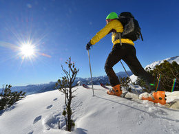
The classic ski tour in the Höllengebirge and the view from the summit cross of the Großer Höllkogel is magnificent
The tour starts at the mountain station of the Feuerkogel cable car. Passing mountain inns, crossing the eastern flank of the Heumahdgupf, you reach the Hintere Edltal valley on trail no. 820.From there, the trail climbs steadily, the landscape profile leads through typical mountain pine lanes over numerous hills uphill and downhill to a fork at the "Totengrabengupf".
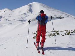
Here you have to decide whether you want to conquer the Höllkogel first, later or not at all. If you keep to the right on the ascent to the ridge, you will reach the Rieder Hütte on the tracks of the "Sommerweg" (the direct hiking trail in summer). Sure-footedness with touring skis is essential, especially when crossing the slopes. From the refuge, you can reach the Großer Höllkogel in three quarters of an hour.
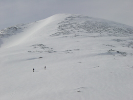
If you continue straight ahead at the Totengrabengupf, you will come to a passage that should not be underestimated: to the left is a depression, to the right is a long slope that some tourers take as a shortcut. But be careful, when there is a lot of snow, this part is dangerous due to the snow deposits, so you should walk through the hollow to be on the safe side.
You then reach the foot of the Großer Höllkogel and have to follow the serpentines uphill to the left until you reach the summit cross of the mountain with its magnificent views.
Descend on the front side in beautiful turns to the Höllkogelgrube, where you put your skins back on and tackle the short section to the Riederhütte. A sunny day at the hut with a view of the conquered mountain - what could be better?
The way back leads along the route of the summer trail or through the Höllkogelgrube on the described route to the Feuerkogel.
Walking time:
Mountain station - Rieder Hütte: approx. 2 hours
Rieder Hütte- Großer Höllkogel: approx. 3/4 hour
Always find out what the general avalanche warning level is.
If necessary, also find out before the tour whether the Riederhütte is open (normally daily from New Year's Eve until the end of the cable car season, usually at the end of March, but not when visibility is poor due to fog).
Parking
- Parking space: 50
General price information
Ticket prices for the Feuerkogel cable car watch www.feuerkogel.info
Payment methods
Debit and credit cards
American Express
ATM card
Mastercard
Visa
Other payment methods
Cash payment
Most economical season
- Early winter
- Deep winter
Please get in touch for more information.
Hauptstraße 34
4802 Ebensee
Phone +43 6133 8016
Fax machine +43 6133 8016 - 870
E-Mail ebensee@traunsee-almtal.at
Web www.traunsee-almtal.at/ebensee
Web www.feuerkogel.info
http://www.traunsee-almtal.at/ebensee
http://www.feuerkogel.info
http://www.feuerkogel.info
Interactive elevation profile
Create PDF
Tour-Details
Starting place: 4802 Ebensee
Destination: 4802 Ebensee
duration: 4h 9m
length: 10,3 km
Altitude difference (uphill): 639m
Altitude difference (downhill): 638m
Lowest point: 1.543m
Highest point: 1.849m
difficulty: medium
condition: medium
panoramic view: Great panorama
Paths covering:
snow, unfixed
powered by TOURDATA