


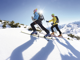
Skitour Weißhorn in Ebensee


Interactive elevation profile
Create PDF
Tour-Details
Starting place: 4802 Ebensee
Destination: 4802 Ebensee
duration: 5h 12m
length: 5,1 km
Altitude difference (uphill): 1.276m
Altitude difference (downhill): 284m
Lowest point: 650m
Highest point: 1.667m
difficulty: medium
condition: medium
panoramic view: Individual Views
Paths covering:
snow, unfixed
powered by TOURDATA
Characteristics:
- moderately difficult ski tour with some steep passages
- Difficulty II
- Avalanche danger: low-moderate, only with fresh snow from the steep flanks in the summit area
From the car park, first follow the wide forest path along the Offensee lake until you turn left towards Hochpafdgraben. After a white water barrier, the path becomes steeper and further up you reach the Hochpfadsattel on a wide path bordered by dense tree cover.
The trail soon descends briefly to the right and through a young forest you come to a forest road, which you follow uphill again to the right. After a hairpin bend, leave this road and climb higher via a steeper forest slope. At around 1,200 metres, you reach flat terrain.
Over several terrain steps with some longer ascents, you climb higher up the Galt-Weißhorn in terrain bordered on the left and right by steep mountain flanks. The storms of the last two years have raged here too, uprooting trees in rows. The route leads higher and over increasingly flatter regions you head through rocky areas (Steinernes Ghag) between the Weißhorn and Roßkogel.
The steep summit ascent then takes you up to the small cross on the Weißhorn with the great views. The descent largely follows the ascent route.
Parking
- Parking space: 10
Most economical season
- Early winter
- Deep winter
Please get in touch for more information.
4802 Ebensee
Phone +43 6133 8016
E-Mail ebensee@traunsee.at
Web www.wander-spass.at
Web www.traunsee.at/ebensee
http://www.wander-spass.at
http://www.traunsee.at/ebensee
http://www.traunsee.at/ebensee
Interactive elevation profile
Create PDF
Tour-Details
Starting place: 4802 Ebensee
Destination: 4802 Ebensee
duration: 5h 12m
length: 5,1 km
Altitude difference (uphill): 1.276m
Altitude difference (downhill): 284m
Lowest point: 650m
Highest point: 1.667m
difficulty: medium
condition: medium
panoramic view: Individual Views
Paths covering:
snow, unfixed
powered by TOURDATA